
If you are entering the world of BIM methodology or if you have been working with it for some time, you will certainly have heard the expression "Scan to BIM" or "Scan 2 BIM". But do you know what this process is and what its benefits are? In this article we will tell you what it is, how it works and some recommendations for working with this tool.
Most projects involve working from an existing asset, for example, a piece of land. Therefore, they should include certain information about these assets to facilitate the development of the project brief, and this information should be available to the main and secondary suppliers that will work on the project.
In certain types of projects, such as refurbishments or expansions, existing assets increase significantly in volume, complexity and importance. Nowadays, the survey of these existing assets can be solved with speed and accuracy thanks to laser scanning and point cloud generation, using Lidar technology.
WHAT IS A POINT CLOUD?
They are millions of digital points geolocated by precise X,Y,Z coordinates that represent their equivalent in the "real" world. These clouds collect the existing conditions of a space, of all the assets that are visible. It is valuable information at different stages of a project's life cycle.

WHAT IS IT FOR?
Mainly to accurately obtain the existing conditions of the assets. These assets can be: land, infrastructure, buildings, equipment and facilities, among others.
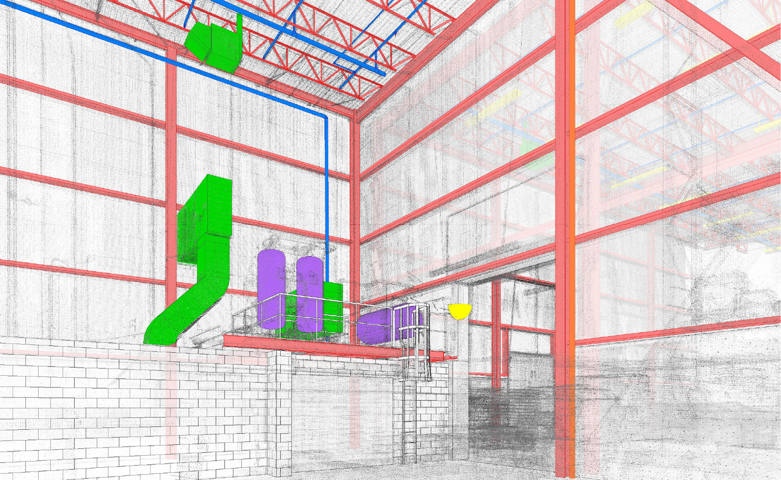
Other more and more frequent uses are to monitor the progress of a work or to survey the final conditions of the work. This last case is necessary when seeking to manage and operate the built assets. “As-built" BIM models are created from the cloud to facilitate the aforementioned use.
HOW CAN I OBTAIN A POINT CLOUD?
Through a 3D laser scan. This can be done through a pedestrian backpack (Leica Pegasus:Backpack), a total station (Leica RTC 360 or Trimble SX10), a mobile handheld instrument (Faro Freestyle3D), a car capable station (Leica Pegasus: Two), drones (Leica Aibot CX) or even airplanes.
Another technique usually associated is photogrammetry, where from several object photos we obtain a three-dimensional representation of an asset. Laser scanning differs mainly in the higher degree of accuracy, although they are often an important complementary input for BIM modeling.
HOW CAN I VISUALIZE A POINT CLOUD?
You can use cloud visualization and manipulation software such as Recap, Leica Cloudworx, Scene or Cloudcompare or you can also insert them directly into BIM modeling software such as Revit, Archicad and Autocad among others.
HOW IS THE "SCAN TO BIM" PROCESS?
In the "Scan to BIM" process a 3D laser scanner is used to perform an accurate survey of the existing conditions. The scanned data is imported into a BIM modeling environment where the as-built models are created, which in our case is Revit.
The "Scan to BIM" process can be divided into 3 fundamental parts:
1. DATA COLLECTION WITH A 3D LASER SCANNER.
This first step is done on site with the point cloud scanner. This can have several formats, such as a scanner fixed to a tripod or a drone, always depending on the downstream objective of the point cloud. These will be controlled from an independent device, which are usually applications for tablets or cell phones.
Here the scanner analyzes by means of a laser beam the distance to the surrounding elements. This results in the registration of a large number of points that are located relatively to the scanner in the X, Y and Z axes, which are precisely those that give the name to the result of the technique. By means of other scans in different locations of the project, the scanner synchronizes the shots with each other to have a "point cloud" of the whole project.
2. DATA PROCESSING
After performing the data scans, it will be necessary to process the results in order to combine them and work with them in the most optimized way possible. This is usually done in independent software of each scanner company, such as Leica Cyclone or Faro Scene. It is also possible to work with ReCap, the point cloud editing software from Autodesk.
When processing data, it is important to keep in mind both the use to be given to the point cloud as well as the available technology we will have to work with the cloud. It is very common for point cloud files to be very heavy, so it is necessary to look for strategies to make them manageable. The most common ones are both to decrease the density of points according to the use, and to divide the cloud into sectors or levels to be able to work without always having to load the entire project.
3. BIM MODELING
Before starting to work with the point cloud in particular, we must coordinate the work ecosystem where we will develop our model. First the project will be studied, the available information will be analyzed, and the base data of the model will be established. These refer to levels, grids and the working views that we will use when modeling the point cloud.
Another important element to establish before starting the modeling is the scope of the modeling, both in terms of entities to be modeled and their level of detail. It will be largely conditioned by the BIM use we give to the model, although it is something that must be coordinated at this stage.
Finally, and once we have our file linked to the modeling software, we use the point cloud to generate the geometry of the as-built model. This model will be enriched with the characteristics and attributes of all the information received (both physical, such as the point cloud, and complementary, such as brands and models of the equipment or photos and videos that give us visual information of the project). Everything must be properly incorporated into the final product, as well as properly organized and structured, so that it is easily readable from any other BIM software and not only by an expert in the field.
BENEFITS OF "SCAN TO BIM
Creates a highly accurate three-dimensional digital representation of assets (land, infrastructure, buildings, etc.) in a reduced time.
Eliminates the degree of error of traditional survey processes.
Increases the reliability of as-built documentation.
Information can be shared more efficiently.
Teams only need to visit the site once to collect data.
IN WHAT SITUATIONS CAN YOU CONSIDER IMPLEMENTING "SCAN TO BIM"?
BIM modeling of existing architectural, structural, sanitary, mechanical, electrical, fire, solar and surveying assets.
Work monitoring.
BIM construction progress certifications.
As Built" BIM modeling for asset management and operation.
Survey of sanitary, mechanical, electrical and fire installations.
Survey of industrial plants.
Civil infrastructure survey.
Survey of logistic warehouses.
Plans for fire projects.
RECOMMENDATIONS FOR WORKING WITH POINT CLOUDS
Working with 2 monitors is especially useful. Place the 360 image viewer or other input on one of them, and the modeling software with the cloud inserted on the other.
It is convenient to request all existing information (reports, plans, memories, etc.). Often it is not available, but if it is, modeling will be faster, more accurate and rework will be reduced.
A robust image and/or video base is very important to facilitate the understanding of the assets and, therefore, the modeling. The survey team should be asked to provide, in addition to the cloud files, the 360 images of each scan performed. There are several formats depending on the data processing software, so it must be coordinated which will be the final format received and the software with which they can be visualized (.RCP and .RCS from ReCap, .LGS from Leica, etc.).
Point densities are variable depending on use and asset. Recommended:
100 x 100 cm grids for LiDAR projects. 30 x 30 cm grids for infrastructure projects. 3 x 3 cm grids for building projects. 1 x 1 cm grids for projects with a high level of detail, such as monuments or ornaments.
When receiving point clouds, it is good to lighten them. A good option is to use the Undet add-in (https://www.undet.com/purchase-undet-for-revit/). This add-in has allowed us to reduce clouds from 300gb to 9 gb.
Understand the logic of the systems before starting. For example, identify structural patterns or the operation of the drainage, mechanical and fire systems. By making hypotheses of the engineering operation that are progressively validated or adjusted, the modeling becomes more fluid.
Understand the uses and objectives of the requested BIM model before starting. This will define the level of information needed and the granularity of the entities. Therefore, optimize the use of time and economic resources. We recommend validating the BEP with the client before starting.
It is recommended to structure the project files correctly. It is often important to divide by sets of disciplines (architecture and structure on one side, and MEP on the other). Once the models have reached a high level of progress, they can be subdivided into more disciplines, since the systems will be recognized in a better way.
Start the modeling from the largest and clearest, and increase the precision (dimensions, insulation, slopes, etc.) progressively, as you go deeper into the project.
SCAN TO BIM IN AXET
In 2019 we made a strategic alliance with an engineering company to model the existing conditions of the projects from the information obtained with laser scanners and translated into point clouds.
With this alliance we seek to remain at the forefront of technology and provide a comprehensive service for the different stages of the BIM life cycle. This way we increase the quality and consistency of our work. We also provide our clients with the possibility of obtaining highly accurate surveys of existing conditions.
While our partner provides all its experience in LiDAR data, in Axet we develop the BIM information models from which the necessary graphic data can be obtained.
For inquiries about these services please write to hello@axetbim.com

